The Cosmos Adventure - The Plan - Leg 2
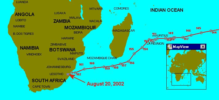
The Cosmos left Whangarei, New Zealand on April 15, 2002, crossing the Tasman Sea to Australia and the Great Barrier Reef. After cruising the north coast of Australia, she set out across the Indian Ocean to South Africa, stopping at several island nations along the way. Cosmos arrived in Durban, South Africa in August, 2002.
Cosmos Route Map - Leg 2
|
Cosmos Location and Distance Chart - Leg 2
The highlighted links in the Location and Distance Chart will take you to the web sites containing a map and interesting facts about the location.
Date |
Way Point | Location |
Latitude |
Longitude |
Leg Dist (Miles) |
Cuml Dist (Miles) |
Mar 29-Apr 15, 02 |
82 |
Whangarei, NZ Town Basin Marina | 35o54'S | 174o20'E | 16.69 | 10,131.07 |
Apr 16, 02 |
83 |
35o28'S | 174o43'E | 36.84 |
10,167.91 | |
Apr 17, 02 |
84 |
At sea | 35o32'S | 174o41'E | 4.97 | 10,172.88 |
Apr 18, 02 |
85 | 35o11'S | 174o23'E | 29.53 | 10,202.41 | |
Apr 19, 02 |
86 |
At sea |
35o04'S | 174o07'E | 17.14 | 10,219.55 |
Apr 20, 02 |
87 |
At sea |
34o02'S | 172o54'E | 99.61 | 10,319.16 |
Apr 21, 02 |
88 |
At sea |
32o50'S | 169o51'E | 195.04 | 10,514.20 |
Apr 22, 02 |
89 |
At sea |
31o43'S | 167o08'E | 177.04 | 10,691.24 |
| Apr 23, 02 | 90 | At sea | 30o45'S | 165o04'E | 139.60 | 10,830.84 |
| Apr 24, 02 | 91 | At sea | 29o52'S | 163o08'E | 130.90 | 10,961.74 |
| Apr 25, 02 | 92 | At sea | 28o58'S | 161o23'E | 122.70 | 11,084.44 |
| Apr 26, 02 | 93 | At sea | 28o07'S | 159o45'E | 115.60 | 11,200.04 |
| Apr 27, 02 | 94 | At sea | 26o39'S | 157o44'E | 160.33 | 11,360.37 |
| Apr 28, 02 | 95 | At sea | 25o56'S | 155o52'E | 126.29 | 11,486.66 |
| Apr 29, 02 | 96 | At sea | 24o55'S | 154o02'E | 134.69 | 11,621.35 |
| Apr 30-May 1, 02 | 97 | At sea | 23o54'S | 152o23'E | 125.75 | 11,747.10 |
| May 2, 02 | 98 | At sea | 21o48'S | 150o33'E | 186.51 | 11,933.61 |
| May 3-5, 02 | - | On Anchor, Mackay Harbor, Au | - | - | - | - |
| May 6, 02 | 99 | At sea | 20o48'S | 149o08'E | 114.77 | 12,048.38 |
| May 7, 02 | - | On Anchor, Nara Inlet, Au | - | - | - | - |
| May 8, 02 | 100 | At sea | 20o04'S | 148o54'E | 52.87 | 12,101.25 |
| May 9-10, 02 | 101 | On Mooring, Manta Ray Bay | 20o04'S | 148o57'E | 3.25 | 12,104.50 |
| May 11, 02 | 102 | At sea | 19o13'S | 147o20'E | 120.95 | 12,225.45 |
| May 12, 02 | 103 | On anchor for lunch in Hutchingbrook Channel | 18o20'S | 146o08'E | 98.60 | 12,324.05 |
| May 13, 02 | 104 | On Anchor, Coates Reef | 17o11'S | 146o21'E | 80.68 | 12,404.73 |
| May 14-17, 02 | 105 | On Anchor, Cairns, Au | 16o55'S | 145o47'E | 41.30 | 12,446.03 |
| May 18, 02 | 106 | On Mooring, Steve's Broomie, Ribbon Reef #3 | 15o31'S | 145o46'E | 96.69 | 12,542.72 |
| May 19, 02 | 107 | At sea | 15o24'S | 145o43'E | 8.72 | 12,551.44 |
| May 20, 02 | 108 | On Mooring, Pixie's Pinnacle, Ribbon Reef #9 | 14o55'S | 145o40'E | 33.55 | 12,584.99 |
| May 21, 02 | 109 | At sea | 13o57'S | 144o20'E | 111.82 | 12,696.81 |
| May 22-24, 02 | 110 | On Anchor, Lloyd Bay, Au | 12o51'S | 143o21'E | 100.93 | 12,797.74 |
| May 25, 02 | 111 | At sea | 11o16'S | 142o54'E | 113.53 | 12,911.27 |
| May 26, 02 | 112 | On Anchor, Thursday Island, Au | 10o35'S | 142o13'E | 66.33 | 12,977.60 |
| May 27, 02 | 113 | At sea | 10o46'S | 140o32'E | 115.66 | 13,093.26 |
| May 28, 02 | 114 | At sea | 10o47'S | 138o15'E | 154.89 | 13,248.15 |
| May 29, 02 | 115 | At sea | 10o49'S | 135o54'E | 159.40 | 13,407.55 |
| May 30, 02 | 116 | At sea | 10o48'S | 133o17'E | 177.48 | 13,585.03 |
| May 31, 02 | 117 | At sea | 11o52'S | 131o28'E | 144.05 | 13,729.08 |
| Jun 1-10, 02 | 118 | On Anchor, Fanny Bay, Darwin, Au | 12o25'S | 130o49'E | 58.24 | 13,787.32 |
| Jun 11, 02 | 119 | At sea | 12o56'S | 128o50'E | 139.38 | 13,927.84 |
| Jun 12, 02 | 120 | King George River, AU | 13o52'S | 127o12'E | 127.41 | 14,055.25 |
| Jun 13, 02 | 121 | At sea | 14o31'S | 125o09'E | 145.55 | 14,200.80 |
| Jun 14-15, 02 | 122 | Shelter Bay, AU | 15o52'S | 123o32'E | 143.17 | 14,343.97 |
| Jun 16-18, 02 | 123 | Lacepede Islands, AU | 17o01'S | 121o60'E | 129.28 | 14,473.25 |
| Jun 19, 02 | 124 | Cable Beach, Broome, AU | 17o54'S | 122o14'E | 62.27 | 14,535.52 |
| Jun 20, 02 | 125 | At sea | 18o00'S | 120o12'E | 133.75 | 14,669.27 |
| Jun 21, 02 | 126 | At sea | 17o34'S | 118o05'E | 143.18 | 14,812.45 |
| Jun 22, 02 | 127 | At sea | 17o07'S | 115o52'E | 150.25 | 14,962.70 |
| Jun 23, 02 | 128 | At sea | 16o39'S | 113o34'E | 156.27 | 15,118.97 |
| Jun 24, 02 | 129 | At sea | 16o01'S | 111o19'E | 156.56 | 15,275.23 |
| Jun 25, 02 | 130 | At sea | 15o08'S | 108o58x' | 168.70 | 15,443.93 |
| Jun 26, 02 | 131 | At sea | 15o00'S | 106o17E | 179.15 | 15,623.08 |
| Jun 27, 02 | 132 | At sea | 14o19'S | 103o53E | 168.10 | 15,971.18 |
| Jun 28, 02 | 133 | At sea | 13o46'S | 102o09E | 122.86 | 15,914.04 |
| Jun 29, 02 | 134 | At sea | 13o09'S | 100o13E | 137.42 | 16,051.46 |
| Jun 30, 02 | 135 | At sea | 12o01'S | 98o08E | 161.41 | 16,212.87 |
| Jul 1-8, 02 | 136 | Destination Island, Cocos Keeling, AU | 12o05'S | 96o53E | 84.51 | 12,697.38 |
| Jul 9, 02 | 137 | At sea | 12o47'S | 94o29E | 169.89 | 16,467.27 |
| Jul 10, 02 | 138 | At sea | 13o35'S | 91o45E | 193.01 | 16,660.28 |
| Jul 11, 02 | 139 | At sea | 14o28'S | 88o39E | 217.71 | 16,877.99 |
| Jul 12, 02 | 140 | At sea | 15o19'S | 85o19E | 231.40 | 17,109.39 |
| Jul 13, 02 | 141 | At sea | 16o02'S | 82o22E | 203.45 | 17,312.84 |
| Jul 14, 02 | 142 | At sea | 16o43'S | 79o30E | 196.83 | 17,509.67 |
| Jul 15, 02 | 143 | At sea | 17o09'S | 77o28E | 138.42 | 17,648.09 |
| Jul 16, 02 | 144 | At sea | 17o41'S | 74o39E | 190.31 | 17,838.40 |
| Jul 17, 02 | 145 | At sea | 18o12'S | 71o37E | 201.65 | 18,040.05 |
| Jul 18, 02 | 146 | At sea | 18o55'S | 68o31E | 211.92 | 18,251.97 |
| Jul 19, 02 | 147 | At sea | 19o33'S | 65o58E | 172.87 | 18,424.84 |
| Jul 20-23, 02 | 148 | On anchor at Port Mathurin, Rodrigues, Mauritius | 19o41S | 63o25E | 166.11 | 18,590.95 |
| Jul 24, 02 | 149 | At sea | 19o39'S | 63o06E | 20.84 | 18,611.79 |
| Jul 25, 02 | 150 | At sea | 19o49'S | 60o32E | 167.10 | 18,776.89 |
| Jul 26, 02 | 151 | At sea | 19o55'S | 58o00E | 164.76 | 18,943.65 |
| Jul 27, 02 | Port Louis, Mauritus | - | - | - | - | |
| Jul 28, 02 | 152 | At sea | 20o11'S | 57o20E | 47.24 | 18,990.89 |
| Jul 29-Aug 1, 02 | 153 | Port Reunion, Reunion | 20o09'S | 55o30E | 118.85 | 19,109.74 |
| Aug 2, 02 | 154 | At sea | 22o29'S | 53o17E | 215.69 | 19,325.43 |
| Aug 3, 02 | 155 | At sea | 24o18'S | 50o51E | 199.46 | 19,524.89 |
| Aug 4, 02 | 156 | At sea | 26o26'S | 49o09E | 181.85 | 19,706.74 |
| Aug 5, 02 | 157 | At sea | 27o07'S | 46o37E | 163.94 | 19,870.68 |
| Aug 6, 02 | 158 | At sea | 27o43'S | 44o11E | 155.55 | 20,026.23 |
| Aug 7, 02 | 159 | At sea | 28o01'S | 41o30E | 165.96 | 20,192.19 |
| Aug 8, 02 | 160 | At sea | 28o14'S | 38o36E | 177.22 | 20,369.41 |
| Aug 9, 02 | 161 | At sea | 28o34'S | 35o22E | 198.75 | 20,568.16 |
| Aug 10, 02 | 162 | At sea | 29o24'S | 32o37E | 176.60 | 20,744.76 |
| Aug 11-20, 02 | 163 | Durban, South Africa | 29o32'S | 31o02E | 96.11 | 20,840.87 |
|
|
 |
